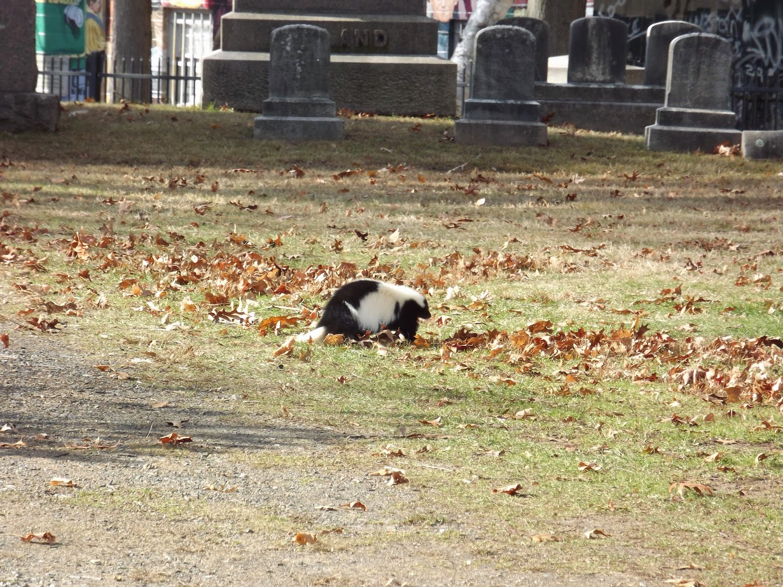
With apologies to Avery Monsen and Jory John.
Back in October one of my friends posted on Facebook talking about a cemetery she was about to visit in Hartford. It was, she said, where Katharine Hepburn is buried. Not long after that I invited myself down to see her, and we managed to coax another friend from our college track team to make the drive from New York to join us.
The cemetery in question is Cedar Hill. After having brunch Coach drove us there, and we left the car near the entrance. The grounds are large, well-kept--though there were large drifts of leaves that were treacherous, as we couldn't tell what the ground did under them--and a bit hilly. Though it was chilly and windy, it was a nice day for it; lots of leaves had fallen but some were still hanging on, and the Japanese maples throughout the grounds were particularly vivid.
One of the notable residents of Cedar Hill is Samuel Colt of firearms fame. You can still see the Colt factory from I-91 as you drive through Hartford, so it's no big surprise that he's buried in the city. His family's monument is made of pink stone, carved in Egyptian motifs and accented with bronze. It's large, but not as ostentatious as some of the other monuments there.
On the other hand, you could miss the Hepburn family's plot if you weren't looking for it. A large stone carved with the family name is all but hidden under two bushes; directly in front of it are the parents' plaques, set into the ground, and the four children's in front of that (Katharine's is second from left in the photo). Each plaque is engraved simply with a name and dates, with no mention of occupation or achievements. It's both admirable in its simplicity, and a little anticlimactic that such a famous woman has such a plain memorial.
Not far away is the tomb of J.P. Morgan. The family's monument is big, and I'm sure it cost a hefty sum, but again, it's not as grandiose as I might have expected. Then again, according to the visitors' guide, the monument is supposed to represent Morgan's "vision" of the Ark of the Covenant; I'm assuming by vision they mean idea, not revelation, but whatever the case, that does add that bit of extravagance and self-importance one might associate with someone like Morgan.
Of course, there are lots of non-famous people buried there, some of whom have interesting headstones, memorials, or mausoleums. One that really stuck out was the Hanson family's. I don't know who these particular Hansons are, but they've got two things going for them. The first is that their monument features a carving based on Scandinavian runestones, and includes a runic inscription (though I will say that I think they ought to have chosen a different lettering style for the family name, as my opinion is that the one used doesn't fit well with the rest of the carving). The second is that the monument is right in front of a pair of large and glorious threadleaf Japanese maples. At any other time of year it probably wouldn't have been as striking, so we went at just the right time.
And then we went to an Irish pub and had some nachos with pastrami on and I had a really good cider. When I grow up I want to be able to hang around in cemeteries and drink good cider all the time.
Tuesday, December 16, 2014
Friday, December 5, 2014
Cemetery Shaming
You'd think the cemetery that was the eternal home to one of the greatest poets in American history would be better taken care of.
I was heading toward Amherst the week before Thanksgiving and decided to do a quick check to see if there were any cemeteries there that I ought to visit. To my surprise I saw that Emily Dickinson is buried in Amherst's West Cemetery. Even if it didn't appear that there were many colonial or Revolutionary graves there, I still had to stop in to see Dickinson.
Despite being on the National Register of Historic Places, West Cemetery is disappointing. It could be a really great cemetery to visit--it's ever so slightly hilly, with a few nice trees scattered around, and clear paths for driving. Whoever manages the cemetery can't be blamed for the fact that the ground is uneven and pocked with small holes that make walking a bit treacherous. But there are many broken, fallen, or precariously leaning stones, which I'm willing to attribute to the soil itself; but I can find little excuse for the trash--not just litter, but bags of trash and what appear to be pieces of clothing--left around the grounds.
There are many Dickinson graves there, but the important one is easy to find (that's it, second from left above). Emily and her family are fenced off by what would be a nice iron fence, provided by distant relatives, but for two things: one, that the fence is only a few inches from the carved face of the tombstones, and therefore two, that the fence passes right over where the Dickinsons are actually buried.
As you might expect at a famous poet's grave, people have left little tokens for Dickinson. There are small rocks piled on top of her headstone, along with pens and a necklace or bracelet; that all makes a fair amount of sense. The framed picture of John Lennon and the gray Converse high-tops make a little less sense to me, but then again, the cemetery is within walking distance of the UMass campus, and you know what English majors are like.
The most exciting part of visiting West Cemetery came as I was getting back in the car and saw a skunk trundling around. I've seen cats and squirrels and chipmunks in cemeteries before, but this was a first for skunks. So my verdict is go see Emily Dickinson if you like, but don't expect too much, and watch out for the wildlife.
On a practical note, Google seems to believe that the cemetery is at 586 S. Pleasant St. It isn't. That appears to be someone's house. I used the entrance on Triangle St., but it might also be possible to enter from N. Pleasant.
Sunday, November 23, 2014
Flashback: A Long Drive
You can drive
nearly from one coast to the other in five days (and fewer if you can power
through more than eight or so hours a day behind the wheel), but I wouldn’t really
recommend it.
To see everything of interest between southern California
and southern Connecticut would take a very long time. I daresay we’d still be driving if we’d been
able to stop at every place we saw in a guidebook that caught our
interest. But, of course, even with time constraints, we did get to
make a few stops, each of us getting to see something that particularly
appealed to us, and we all survived and my new old car survived and those are
the important things.
At the beginning of August Mom and Dad and I drove across the country to get me and
said new old car, christened the Bluebird after Dad saw a bus from that
company, to grad school (again, though a different school and a different degree than last time). There
are two basic ways you can get from our Point A to Point B: by taking I-40,
which cuts through the Southwest before heading into Missouri and so on, or by
taking I-80, which starts out going north through Utah and then heads east. We chose the latter route, though with a bit of a detour. While the most direct route involves taking
I-70 through Colorado and picking up I-80 in Nebraska, we decided to stay on I-15 all
the way through Utah and meet 80 in Wyoming, because we wanted to see Wyoming
(and I, for one, wanted to avoid driving through big mountains as much as
possible). The biggest downside to our chosen route was that there was a lot of road work going on on 80; perhaps if we had known this beforehand we would've gone a different way, and it's a bit of a surprise that the AAA office didn't warn us about the issue.
Before we left we had a few places that we intended to stop, in Iowa and Indiana and Pennsylvania, but we didn’t make any hotel reservations ahead of time so that we could drive as far as we wanted to on any given day. It was a logical notion that didn’t necessarily pan out in real life.
(Our ideal plan had been to leave 80 around Toledo, drive
through Detroit and across the bridge into Canada, and then come down from the
north somewhere. This plan was foiled by
the fact that somebody on our trip
let her passport expire. It’s less than
three and a half hours from my current location to the border, though, and just
under four to Montreal, so you know that that’s going to happen at some point.)
With Dad and I taking turns, I drove about half of the
time. My shifts ended up being from:
the Arby’s in Baker, CA, to Arshel’s restaurant in Beaver, UT (after leaving Beaver, above)
Evanston, WY, to Wamsutter, WY
Sidney, NE, to the western edge of Lincoln, NE
Adair, IA, to near Brooklyn, IA*
Walcott, IA, to possibly Channahon, ILthe Arby’s in Baker, CA, to Arshel’s restaurant in Beaver, UT (after leaving Beaver, above)
Evanston, WY, to Wamsutter, WY
Sidney, NE, to the western edge of Lincoln, NE
Adair, IA, to near Brooklyn, IA*
Valparaiso, IN, to near Howe, IN
somewhere between Toledo and Akron, OH, to Shenango Valley, PA
State College, PA, to somewhere quite close to the New York-Connecticut border when my nerves finally gave up on me and I had to let Dad drive the 15 or so minutes left to our final destination
I don't have as many pictures as you might expect from the trip because of all the time I spent behind the wheel.
On our very first night we learned that you can’t just roll
into Provo on a Wednesday night and expect to find vacant hotel rooms. This did not, however, mean that we
immediately got online and made reservations for the rest of our nights. Except for the places we knew we were going
to stop, we left our accommodations to chance.
I'd venture to say that the worst road we had to deal with was in Indiana. Hoosiers, I am disappointed in you. You dare to charge people to drive on that section of interstate? Where is that toll money going? It's certainly not going toward the upkeep of your roads.
I think my favorite scenery of the trip was from Utah into
Wyoming. I know my favorite driving was
in Wyoming, and not just because you can go 80 miles per hour; southern Wyoming
is very pretty, with lots of rolling hills and green grass and not a lot
else. On the western end of our route
there’s a lot of open space between the cities.
That openness disappears the further east you go, with ranges giving way
to farmland, denser populations, and more trees appearing. It seemed as though the trees had swallowed
all of Pennsylvania, and after the days of horizon it felt suffocating to have
them looming overhead.
One of our serendipitous
finds was a Czech restaurant in Omaha called Bohemian Café. Since it was a Czech place there was no halušky on the menu, nor did
they have any Kofola or even Vinea, but the food was good nonetheless. There was soup and pork and knedľa and poppyseed cake,
and you don’t really need much else after you’ve been deprived of a good
Central European meal for too long.
I feel confident in
saying that the highlight for my dad was stopping in Iowa at Iowa 80, the world’s
largest truck stop. It’s huge. One room has truck accessories for sale but
it also has a full tractor-trailer and two rigs on display. There’s a food court and like four different
gift shops and showers and a chapel and a museum and a dentist's office, and parking for hundreds of
trucks and even more cars. It was pretty
amazing.
If I ever make this drive, or even part of it, again, I'm going to make sure there's plenty of time for stopping places. Or I'll hire someone to drive for me, like that couple did with the cab driver. That sounds more like it.
The uncertainty is due to the fact that many of our
trade-offs took place at gas stations or rest stops, which all sort of start to
look alike after a few hundred miles.↩
Friday, November 14, 2014
Castle Run
A few weeks ago one of my former students shared a video on Facebook of a bunch of guys freerunning and parkouring around Spiš Castle. This was done with the castle's permission, because it was a professional video with sponsors and everything. The group, Born To Trick, has made a series of these videos called "Castle Run"; there are eight of them, each filmed in a different Slovak castle. This morning the poor soul who has the dubious distinction of being my best Slovak friend sent me a link to this video, done at Orava Castle. I can't imagine leaping about in that castle, where I felt so dizzy even when I looked at the pictures of it when I got home. Though I've not seen all of the videos yet, this one might end up being my favorite; besides the parkour it also features folk dancers, and that's what Slovakia is. It's people who are proud of their country, its culture and its natural beauty, and that celebrate that while embracing modern life.
Wednesday, October 29, 2014
In which I am better prepared
Earlier this week I was feeling tempted to go to Salem to see how insane it was the week before Halloween. It's nearly two hours from here to there, though, so common sense prevailed in the end. Instead I looked at my list of burying grounds/historic cemeteries in this general area and decided I could take a little time to visit the Old Hadley Cemetery, a mere quarter of an hour away.
(Maybe someday I'll visit a place in Mass that's not a cemetery. But they're so pretty in autumn, and I'm not about to pass up the chance to see old graves.)
Old Hadley Cemetery is located on Cemetery Road, across from a cornfield and adjacent to a now-harvested field of something. That's the road and the cornfield above, along with the blur of a leaf in the process of falling. I found information about the cemetery, and the coordinates for directions, on Grave Addiction. Probably three-fourths of the graves are from the late 19th and 20th centuries. The grass was trimmed short, and though it looked a little dry, it had obviously been looked after recently. I first stopped near where I thought there might be some old stones, but when they turned out to be 19th century I moved the Bluebird closer to where the old graves really were, which Grave Addiction tells me is the west end of the cemetery.
These oldest graves haven't been moved from anywhere else; the cemetery was established in the 17th century. Though I'd read that before I visited, I sort of forgot about it for a while, and was therefore surprised when I came across graves from that far back. The old section had the most trees, and therefore the most leaves on the ground, but not in a hazardous manner. Near the short iron fence (short enough that I was prepared to get myself over it if the gates had been locked) that ran along Cemetery Road was a strange lump of a hill that turned out to be a mausoleum facing the road; you can see it on the left in the first picture on the page. The year 1859 was carved on the lintel, but there was no sign of a family name.
In this old section are members of some of the area's colonial families; a plaque in a rock says that Nathaniel Dickinson, who was born in England, founded Hadley in 1659 and died there in 1676. Surrounding the rock are plenty of Dickinson graves, like that of Captain William Dickinson's at left, who died at 67 on June 24, 1742. There are also people whose names have made it into street names in the area, like Lymans and Chileabs.
As I made my way from the street side further back, the graves generally got older. The ones nearest the road were late 18th century; towards the middle they were mid-18th. I saw a 1742 death date and was excited about that until I came across a 1725. Then there was a 1718, and then a pair of stones raised like tabletops, illegible with age but with plaques in front of them indicating that they were of Rebekah (below) and the Reverend John Russell, who died in 1688 and 1692. Original 17th century gravestones! There were also a few replacement markers for graves from the same era, like the one at right, but originals are so much better. Shortly thereafter my camera's batteries gave up, but I was well satisfied.
I was struck by the extreme simplicity of the early 18th-century stones when compared with those from the late 18th century. Captain Dickinson's headstone just has the barest facts, carved in simple capitals with no decoration, while by the time of the Revolution most stones have more information, variation in typography, and symbolic ornaments. Perhaps the matter-of-factness of the early headstones is a mixture of humility and austerity.
On a final note, I feel like I'm getting better at photographing graves. It helps to try to get as level with the face of the stone as you can. I did a lot of squats yesterday.
(Maybe someday I'll visit a place in Mass that's not a cemetery. But they're so pretty in autumn, and I'm not about to pass up the chance to see old graves.)
Old Hadley Cemetery is located on Cemetery Road, across from a cornfield and adjacent to a now-harvested field of something. That's the road and the cornfield above, along with the blur of a leaf in the process of falling. I found information about the cemetery, and the coordinates for directions, on Grave Addiction. Probably three-fourths of the graves are from the late 19th and 20th centuries. The grass was trimmed short, and though it looked a little dry, it had obviously been looked after recently. I first stopped near where I thought there might be some old stones, but when they turned out to be 19th century I moved the Bluebird closer to where the old graves really were, which Grave Addiction tells me is the west end of the cemetery.
These oldest graves haven't been moved from anywhere else; the cemetery was established in the 17th century. Though I'd read that before I visited, I sort of forgot about it for a while, and was therefore surprised when I came across graves from that far back. The old section had the most trees, and therefore the most leaves on the ground, but not in a hazardous manner. Near the short iron fence (short enough that I was prepared to get myself over it if the gates had been locked) that ran along Cemetery Road was a strange lump of a hill that turned out to be a mausoleum facing the road; you can see it on the left in the first picture on the page. The year 1859 was carved on the lintel, but there was no sign of a family name.
In this old section are members of some of the area's colonial families; a plaque in a rock says that Nathaniel Dickinson, who was born in England, founded Hadley in 1659 and died there in 1676. Surrounding the rock are plenty of Dickinson graves, like that of Captain William Dickinson's at left, who died at 67 on June 24, 1742. There are also people whose names have made it into street names in the area, like Lymans and Chileabs.
As I made my way from the street side further back, the graves generally got older. The ones nearest the road were late 18th century; towards the middle they were mid-18th. I saw a 1742 death date and was excited about that until I came across a 1725. Then there was a 1718, and then a pair of stones raised like tabletops, illegible with age but with plaques in front of them indicating that they were of Rebekah (below) and the Reverend John Russell, who died in 1688 and 1692. Original 17th century gravestones! There were also a few replacement markers for graves from the same era, like the one at right, but originals are so much better. Shortly thereafter my camera's batteries gave up, but I was well satisfied.
the Russells' graves at center
I was struck by the extreme simplicity of the early 18th-century stones when compared with those from the late 18th century. Captain Dickinson's headstone just has the barest facts, carved in simple capitals with no decoration, while by the time of the Revolution most stones have more information, variation in typography, and symbolic ornaments. Perhaps the matter-of-factness of the early headstones is a mixture of humility and austerity.
On a final note, I feel like I'm getting better at photographing graves. It helps to try to get as level with the face of the stone as you can. I did a lot of squats yesterday.
Saturday, October 25, 2014
In which I have not learned from my past unpreparedness
Before I left for Springfield on Thursday morning, where I was to get my fingerprints taken, I thought, "Maybe I should take my camera with me."
"Nah," I then thought, "it's supposed to rain." So I left, taking the things I thought I might need but leaving my camera in my room.
When I was nearly to the storefront where the fingerprint place was, in a part of Springfield I'd never been before, I saw on my left a small cemetery with oldish stones surrounded by a carpet of fallen leaves. Right next to it was a much larger one, with an impressive tower in the center. On the left on the way there means on the right on the way back, and on the right means it's easy to turn in. I filed this information away and continued to my appointment.
Once it was finished (those new digital fingerprints are so easy compared to the old way) and I'd gotten a pumpkin pie Coolata at Dunkin Donuts, I made my way back to the cemeteries. The first I came to was the larger, Hillcrest Park as the signs named it; once inside the gates it was easy to see that this was a cemetery in the new style, with no visible stones. Maybe there were some in the back, but all I saw was trees, that big tower, and some Canada geese. It would have been a lovely park, but as a cemetery it was a disappointment. The disappointment was allayed by the fact that I knew there was a better one just next door.
Had I actually brought my camera along, I likely would have spent much longer at Maplewood cemetery. At least I had my camera phone. Even if I'd had the real camera, I don't think the pictures would really do justice to the atmosphere; though it was off a decent sized road it was quiet, and with the thick accumulation of leaves it seemed obvious that no one had been hanging out there recently, making it a little oasis. Unfortunately those leaves also meant that I nearly tripped over a small marker that had been all but hidden. Of course I apologized, and was more careful afterward.
Maplewood hadn't come up in my research on old cemeteries in the area ("old" in this case meaning with graves from the colonial or Revolutionary period); the oldest graves I saw were from the mid-19th century, which is not too shabby.
According to the Internet, Maplewood is now controlled by Hillcrest Park next door. The cemetery is in fairly good condition overall; the grass wasn't too tall, and there weren't any toppled stones. It's even possible the leaves had been cleaned up sometime before my visit, because they've been coming down like nobody's business recently, and I'm sure that accumulation could have happened in a few days, if not overnight. Unfortunately, the leaves covered the place where it was safe to drive, and since I couldn't back out (because I would have been backing out into traffic on a busy street) I had to make an educated guess and hope for the best.
The two main takeaway lessons from this are:
1. Don't trust weather.com and
2. just take your camera, for Pete's sake.
Tuesday, October 21, 2014
Autumn in Western Mass
This blog is owed much update and explanation. I keep thinking I'll get a chance to sit down and write something for it, but it always gets away from me. Here, at least, is some new content.
It's October, and in western Massachusetts that means it rains. Last Friday it rained on and off for most of the day, and from the comfort of my room I got a little of it on video to share. Since that time a lot of the leaves on the tree outside my window have blown down to the ground. I'm not looking forward to the time when they're all gone--I don't feel prepared to see a naked tree outside my window for the next few months. I suppose I'd better get ready.
Subscribe to:
Posts (Atom)